An overview of the historic landscape of the AONB
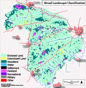
At the most general level the AONB Historic Landscape Characterisation has recorded the broad land use in today's landscape. The map shows the areas of landscape which are enclosed, unenclosed, wooded, parkland, water or used for modern purposes such as recreation.
Click the map for large PDF version(422Kb)
The map strongly reflects the deeply rural nature of the AONB, 80% of the area is characterised as enclosed land - the vast majority of this being farmland.
The woodland in the north of the AONB is still present as contiguous blocks, while it is much more dispersed through the Vale of Wardour to the North east of Shaftesbury and the area to the North of Blandford. The belt of oval woodland which demarks the ride of the designed "Capability Brown style" landscape of Wimborne St Giles can clearly be seen to the South of the A354.
There are small yet significant areas of unenclosed land remaining in the AONB, including the open chalk grassland of Martin Down and the open chalk escarpments to the region to the North of Mere. There is also a small amount of surviving common land at Semley to the North of Shaftesbury.
The parkland and designed landscapes of the AONB provide a small but important feature of the landscape, 2,960 hectares of land retains its parkland character. These landscapes are generally concentrated to the West of the AONB and through the Nadder valley.
The AONB is sparsely populated - much of the settlement is spread along the river valleys especially of the Ebble and Wylye. More nucleated and scattered settlement can be seen in the area between the A303 and A30. There is also a distinctive pattern of settlement following the edge of the wooded Greensand hills in the far North West corner of the AONB.
For more detailed information on the AONB Historic Landscape Characterisation click here.