Other Historic Landscape Types
 The AONB Historic Landscape Characterisation studied and mapped the Historic Landscape character of the AONB. This included very modern features including industrial areas or modern infrastucture and more specialised types of historic land use, for example, in river valleys
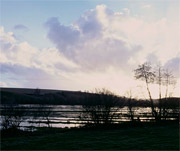
This example focuses on relic Water Meadows which are a locally distinctive feature of the AONB
Meadows played a crucial role in Britain's farming economy between 1600 and 1900. The early grass that could be produced by watered meadows was a crucial element to the farming regimes of the chalklands of Dorset, Wiltshire and Hampshire. The meadows formed a central feature of the local 'sheep corn' system of agriculture.
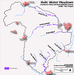
The survival of relic Water Meadows in the AONB can clearly be seen in the map. They cover an area totalling nearly 2000 hectares. They are present along all the main rivers in the AONB: the Wylye, Nadder, Ebble, Allen, Crane and the Tarrant.
Click map for large PDF version (496Kb)
The Water Meadows are comprised of a series of complex and sophisticated bedworks, which used a system of weirs, hatches, channels and drains to drown the meadows. These were interspersed by culverts and bridges, which provided access to the meadows for carts when the hay was harvested. The evidence for these is still visible in the landscape.
For more detailed information on the AONB Historic Landscape Characterisation click here.