Introducing Historic Landscape Areas
 The Area documents summarise the key characteristics of discrete geographical areas within the AONB, they then set out the significance, condition and forces for change affecting the historic fabric and character of each area and identify proactive actions to conserve and enhance its characteristics
The Historic Landscape Character Areas are designed to be used alongside the Historic Landscape Theme descriptions.
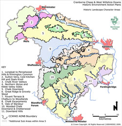
An outline of the main characteristics of each Historic Landscape Character Area in the AONB is available by clicking the appropriate part of the AONB wide map, or by clicking the left hand column of the table.
Alternatively the full Area descriptions can be downloaded from the right hand column
| Area | Full Area Documents |
|---|---|
| Area 1 |
Download Area 01 Longleat to Penselwood and Kilmington Common (PDF 1.2MB) |
| Area 2 |
Download Area 02 Sutton Veny, Cold Kitchen Hill and Zeals Knoll (PDF 1.1MB) |
| Area 3 |
Download Area 03 Chalk River Valleys (PDF 1.0MB) |
| Area 4 |
Download Area 04 Northern Wylye and Ebble Valley Sides (PDF 1.8MB) |
| Area 5 |
Download Area 05 West Wiltshire Downs (PDF 1.4MB) |
| Area 6 |
Download Area 06 Great Ridge and Grovely Woods (PDF 1.4MB) |
| Area 7 |
Download Area 07 Fovant Terrace and and the area between Chalbury and Woodlands (PDF 1.3MB) |
| Area 8 |
Download Area 08 Chalk Escarpments (PDF 1.4MB) |
| Area 9 |
Download Area 09 Vale of Wardour (PDF 1.0MB) |
| Area 10 |
Download Area 10 Wooded Chalk Downland of the Cranborne Chase and Chetterwood (PDF 1.3MB) |
| Area 11 |
Download Area 11 Downland Hills (PDF 2.4MB) |
| Area 12 |
Download Area 12 Southern Downland Belt (PDF 1.2MB) |